

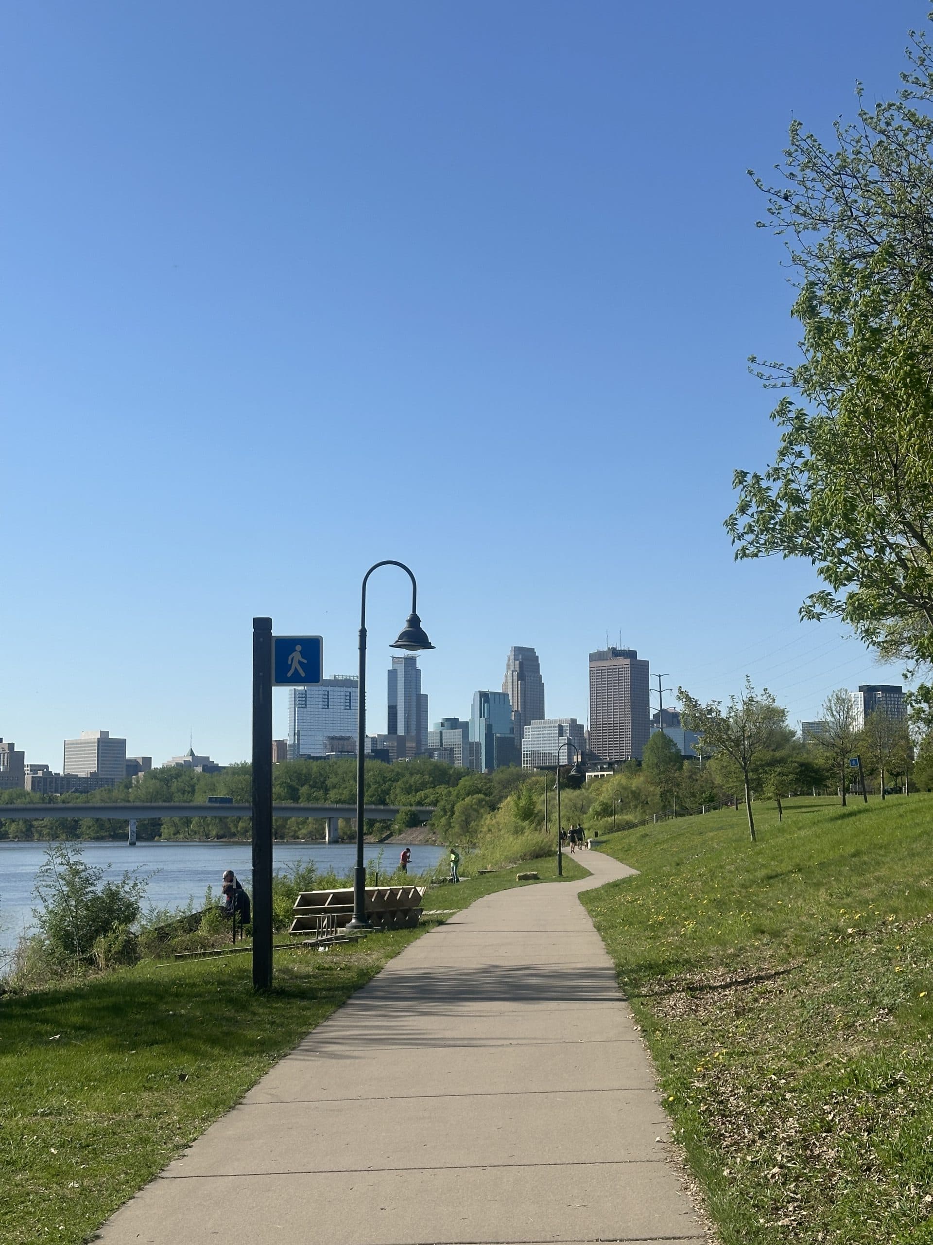
North Loop Riverfront Walks: A Local’s Short List
Key takeaways
- Graco Park (18 minutes, 0.8 mile) and Boom Island Park (20 minutes, 0.9 mile) are the closest riverfront destination parks to Sweetleaves in the North Loop. Both are reached over the Plymouth Avenue Bridge.
- The full riverfront loop from the North Loop to Water Works, across the Stone Arch Bridge and back through Nicollet Island and Boom Island, is 4.2 miles, about 1 hour 34 minutes of walking without stops, according to Google Maps.
- A shorter loop to Boom Island and Nicollet Island and back is 2.6 miles, about 57 minutes.
North Loop riverfront destinations
Six riverfront stops sit within a 40-minute walk of the North Loop. The table lists the walking time and distance to each from 905 N Washington Ave, plus highlights and restroom access.
| Stop | Walk from 905 N Washington Ave | Highlights | Public restrooms |
|---|---|---|---|
| Graco Park | 18 min · 0.8 mi | River walkway, gravel river landing, logging-history public art, a view of restored Hall’s Island | Yes, in The River Hub |
| Boom Island Park | 20 min · 0.9 mi | Picnic areas, a playground, a view of the miniature lighthouse, a footbridge to Nicollet Island | Yes |
| Nicollet Island Park | 29 min · 1.3 mi | A promenade facing the first dam on the Mississippi, the Bell of Two Friends monument | None |
| Water Works at Mill Ruins Park | 28 min · 1.3 mi | Mill ruins, firepits on General Mills Plaza, a lawn above St. Anthony Falls | Yes, in the pavilion |
| Stone Arch Bridge | 32 min · 1.4 mi | A 2,100-foot granite-and-limestone bridge from 1883 with views of St. Anthony Falls | None on the bridge |
| Father Hennepin Bluff Park | 40 min · 1.8 mi | Paths to the river’s edge, falls views, a bandstand | Yes |
The full riverfront loop, step by step
The full loop is 4.2 miles and takes about 1 hour 34 minutes of walking. It follows West River Parkway downriver to the mill ruins, crosses the Stone Arch Bridge, then heads back upriver on the east bank and returns to the North Loop over the Plymouth Avenue Bridge. The route takes in views of the downtown skyline and works as both a people-watching stroll and a workout.
- North Loop to Water Works (1.3 miles, 28 minutes). Head to the river and follow the West River Parkway trail downstream to Water Works at Mill Ruins Park.
- Water Works to Father Hennepin Bluff Park (0.9 mile, 20 minutes). Cross the Stone Arch Bridge to the east bank, with St. Anthony Falls just upstream.
- Father Hennepin Bluff Park to Nicollet Island Park (0.7 mile, 17 minutes). Follow Main Street SE upriver, then cross onto Nicollet Island and follow East Island Avenue.
- Nicollet Island Park to Boom Island Park (0.4 mile, 9 minutes). A pedestrian bridge links the island to Boom Island.
- Boom Island Park back to the North Loop (0.9 mile, 20 minutes). Cross the Plymouth Avenue Bridge and walk back to Washington Avenue.
The middle of the route overlaps the St. Anthony Falls Heritage Trail, a self-guided loop of about 2 miles with interpretive signs. Walking the loop in reverse puts the Stone Arch Bridge near the end.
A shorter walk: Graco Park, Boom Island and Nicollet Island
For a walk of about an hour, stay north of Hennepin Avenue. The loop from 905 N Washington Ave to Boom Island Park, across to Nicollet Island and back is 2.6 miles and about 57 minutes of walking, per Google Maps.
Graco Park sits just north of the Plymouth Avenue Bridge on the east bank, an 18-minute walk from the North Loop. It makes an easy first stop before Boom Island, or a quick out-and-back on its own.
What to see at each stop
Each stop on the loop has its own piece of Minneapolis milling or logging history. The notes below cover what’s there now, including recent openings, restrooms and construction that older guides miss.
Graco Park
Graco Park is a 9.31-acre riverfront park at 810 Sibley St. NE. Its outdoor spaces opened in fall 2024, and The River Hub building followed in April 2025. The park has a river walkway, a gravel river landing for canoes and kayaks, an outdoor stage with sloped lawn seating, and “Timber Markers” public art that nods to the site’s logging past.
From the walkway, look for Hall’s Island. A lumberyard expansion erased the island in the 1960s, and a restoration project rebuilt it in winter 2017 to 2018. The River Hub has public restrooms and is open Wednesday through Sunday, noon to 8 p.m.
Boom Island Park
Boom Island Park, at 724 Sibley St. NE, covers 22.5 acres on the east bank. It was once a log-sorting station for the logging industry, and the back channel that made it an island was later filled in.
The park has picnic areas, a playground and restrooms, and its north end looks out on the miniature lighthouse, which now stands on the southern tip of restored Hall’s Island. A pedestrian bridge connects it to Nicollet Island, and the parking lot closes at 9 p.m.
Nicollet Island Park
Nicollet Island Park, at 40 Power St., covers nearly 27 acres just above St. Anthony Falls. Its promenade looks out on the first dam on the Mississippi River, and the Bell of Two Friends monument stands in the park.
The island’s north end holds Victorian-era homes from the mid-to-late 1800s. The Park Board lists no public restroom at this park, so plan a stop at Boom Island or Father Hennepin Bluff Park.
Water Works at Mill Ruins Park
Water Works, at 425 West River Pkwy., is built around the preserved remnants of Bassett’s Sawmill and the Columbia Flour Mill. General Mills Plaza has three gas firepits, the Bank of America City Steps add terraced seating, and a mezzanine lawn overlooks St. Anthony Falls. The pavilion has public restrooms.
One construction note: the lower Mill Ruins area is currently reached only from the trail entrance near the 35W Bridge Remembrance Garden, with no through access. The park is open 6 a.m. to midnight.
Stone Arch Bridge
The Stone Arch Bridge is a 2,100-foot granite-and-limestone bridge built from 1881 to 1883 for the Minneapolis Union Railroad. Rail use ended in 1982, according to MnDOT, and it now carries people on foot and bikes. MnDOT owns the bridge, and the Park Board maintains its deck.
The bridge fully reopened on July 21, 2025, after repair work, and MnDOT lists the project as complete. Some older travel pages still describe it as partly closed.
Father Hennepin Bluff Park
Father Hennepin Bluff Park, at 420 Main St. SE, covers about 8 acres on the east bank. Paths lead down toward the river’s edge, with views of St. Anthony Falls, and the park has a bandstand and a drinking fountain. A 2023 renovation added a new stage and bathroom building next to the Stone Arch Bridge.
Planning a fall walk
Daylight sets the schedule in late October. On Oct. 20, 2026, the sun sets in Minneapolis at 6:19 p.m., so the full loop fits best with a start by about 4:30 p.m.
- Park hours: most stops on this route are open 6 a.m. to midnight. Undeveloped areas of Father Hennepin Bluff Park close at 10 p.m.
- Restrooms: Water Works, Father Hennepin Bluff Park, Boom Island Park and The River Hub at Graco Park (open Wednesday through Sunday) all list public restrooms. The Park Board notes that restroom hours may vary in fall as daylight shrinks.
- Light rail: Target Field Station, a 15-minute walk from 905 N Washington Ave, is served by both METRO light rail lines.
- Race day: the Minneapolis Halloween Half Marathon, 10K and 5K on Saturday, Oct. 31, start on West River Parkway and cross the Stone Arch Bridge, so expect crowds on the route that morning. Check Park Board closure notices before driving to the river.
Can cannabis be used in Minneapolis parks?
Not by smoking or vaping, and the Park Board authorizes other THC use only in narrow settings. The Minneapolis Park and Recreation Board bars tobacco and “Cannabis or THC products that produce vapor or smoke in any form” on its property, which covers every park on this walk. The ban took effect May 15, 2025, and isn’t enforceable by citation; park staff, including Park Police, may ask a person to leave.
A separate Park Board THC policy authorizes only beverages and edibles with no more than 5 mg of THC per serving, sold at concessions under a Board-approved contract, concession or lease agreement or at Board-permitted events, and consumed in that designated area. The policy makes any other cannabis use in parks subject to Minn. Stat. § 342.09, which names private residences, private property not open to the public and licensed on-site consumption venues as the places adults may use cannabis. Cannabis flower can’t be sold on park property.
Minnesota rules that apply on and around the riverfront
| Situation | The rule | Source |
|---|---|---|
| Smoking or vaping cannabis in a Minneapolis park | Not allowed; staff may ask people to leave | Minneapolis Park Board policy |
| THC drinks or edibles in a Minneapolis park | Only products with 5 mg of THC or less per serving, bought from an approved park concession or permitted event and consumed in its designated area | Minneapolis Park Board THC Policy 2025-72 |
| Smoking or vaping where a minor would breathe it | Not allowed anywhere in Minnesota | Minn. Stat. § 342.09, subd. 1(b)(9) |
| Using cannabis in a motor vehicle | Not allowed, parked or moving | Minn. Stat. § 342.09, subd. 1(b)(2) |
| An opened package in a car on the road | Keep it in the trunk; the glove box doesn’t count | Minn. Stat. § 169A.36 |
The statewide picture, including possession limits and where use is allowed, is in the Minnesota cannabis laws guide.
Where the walks start
Every walking time in this guide starts at 905 N Washington Ave, home of Sweetleaves North Loop, about 0.7 mile from Target Field Station. The times come from Google Maps walking directions checked on Sept. 30, 2026, and can shift with construction or detours.
More on the neighborhood itself is in the North Loop weekend guide.
Frequently asked questions
Which riverfront parks are closest to the North Loop?
Graco Park and Boom Island Park. From 905 N Washington Ave, Graco Park at 810 Sibley St. NE is about an 18-minute walk (0.8 mile) over the Plymouth Avenue Bridge, and Boom Island Park is about 20 minutes away.
How long is the walk from the North Loop to the Stone Arch Bridge?
About 32 minutes. Google Maps puts the west end of the Stone Arch Bridge 1.4 miles from 905 N Washington Ave.
How long is the riverfront loop from the North Loop?
The loop through Water Works, the Stone Arch Bridge, Father Hennepin Bluff Park, Nicollet Island and Boom Island is 4.2 miles. It takes about 1 hour 34 minutes of walking without stops.
Is the Stone Arch Bridge open?
Yes. The Stone Arch Bridge fully reopened on July 21, 2025, after repairs, and MnDOT lists the project as complete.
Is smoking cannabis allowed in Minneapolis parks?
No. Smoking or vaping cannabis or THC products isn’t allowed on Minneapolis Park and Recreation Board property, and park staff may ask people to leave.
Are there public restrooms along the Minneapolis riverfront?
Yes, at Water Works, Father Hennepin Bluff Park, Boom Island Park and The River Hub at Graco Park, which is open Wednesday through Sunday. The Park Board notes that restroom hours may vary in fall.
Sources
- Minneapolis Park and Recreation Board, Alcohol, tobacco and cannabis rules
- Minneapolis Park and Recreation Board, MPRB approves cannabis and THC policies (May 12, 2025)
- Minneapolis Park and Recreation Board, THC Policy 2025-72
- Minneapolis Park and Recreation Board, Graco Park
- Minneapolis Park and Recreation Board, The River Hub at Graco Park
- Minneapolis Park and Recreation Board, Boom Island Park
- Minneapolis Park and Recreation Board, Nicollet Island Park
- Minneapolis Park and Recreation Board, Water Works at Mill Ruins Park
- Minneapolis Park and Recreation Board, Stone Arch Bridge
- Minneapolis Park and Recreation Board, Father Hennepin Bluff Park
- MnDOT, James J. Hill Stone Arch Bridge (Bridge 27004)
- National Park Service, St. Anthony Falls Heritage Trail
- U.S. Naval Observatory, Sun and Moon Data for One Day
- Metro Transit, Target Field Station
- Minnesota Statutes 342.09, Personal adult use of cannabis
- Minnesota Statutes 169A.36, Open package law